 |
|
|
GLOBALBASE Functions
Author: Hirohisa MORI joshua at globalbase.org +
* Abstract
* [1] Data Structure without Reference Coordinate System
* [2] Concept of Mappings Connecting Coordinate Systems
* [3] Distributed Search Engine
* [4] Searching for Mapping Paths Auto-Configured Routing Protocol
* [5] Browsing Method
* [6] Source Code
Abstract
[UP]Go To Page Top
[1] Data Structure without Reference Coordinate System
In the process of decentralization, the first problem we encounter is the coordinate system. Current GISs have a single reference coordinate system, and all information must conform to it. This approach, however, leads to a qualitative bottleneck.
In GLOBALBASE, all coordinate systems are relative and can be defined individually by the user. In order for many people to be able to deliver geographical information freely and for such information to be shared to create one map of the Earth, GLOBALBASE must be able to handle maps created by normal drawing software as well as maps created by survey institutes in a consistent manner. To achieve this, being able to operate on user-defined coordinate systems is a necessity in order to deal with coordinate systems of different drawing software packages.
All the current GISs employ a single coordinate system that is used as reference. Such a coordinate system prohibits fusion of data from other fields that use different coordinate system concepts; this is one of the primary reason why the GIS technology has not achieved as great a degree of diffusion as expected. The common belief that GIS technology is difficult to use or requires expertise in geography, surveying etc., has given it a negative image.
By implementing user-definable coordinate systems, it becomes possible to capture any information within the same framework, from layouts drawn with drawing tools or architecture CAD software to layouts of rooms and show windows. However, since the only way to connect all this diversified information is through the use of distributed technologies, there must also be a method to integrate all the different fields in order to create one geospace.
[UP]Go To Page Top
[2] Concept of Mappings Connecting Coordinate Systems
What will happen if each individual defines an arbitrary coordinate system? We no longer know the relationship between such individual, arbitrary coordinate systems. Fortunately, the technology called mapping presents a solution to this problem.
Let us assume that a person whose hobby is gardening draws a picture of the layout of his garden in order to present his new garden to other people. He then pastes it onto a Japanese map made available at the International Research Center for Japanese Studies at the location corresponding to his home.
The relationship between the layout of the garden and the Japanese map only needs to describe where the four corners of the garden are situated on the Japanese archipelago. A mapping is a list of such correspondences between the coordinates of the four points in the "garden" coordinate system and the corresponding coordinates in the "Japanese archipelago" coordinate system. By providing this mapping, the garden layout is connected to the Japanese archipelago, i.e., users can now find the garden by zooming in on the map of the Japanese archipelago.
A mapping plays the role of a bi-directional link; please refer to Fig.(Coordinate Systems and Mappings)Coordinate systems are indicated by rhombs and mappings defining the relationships between coordinate systems are indicated by ovals. Mappings and coordinate systems can be placed on any server, because the mappings work as links beyond the confines of the servers.
Currently, mapping processing must be manually edited by information providers, but in the future, mapping editors and drawing editors supporting GLOBALBASE will become available. When that happens, it will become possible to paste one's own "garden" onto a map of the Japanese archipelago on another server just by dragging and dropping a control point in the drawing software.
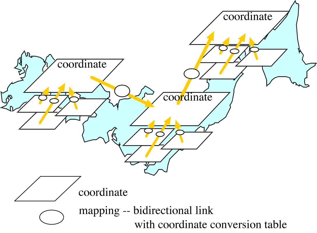
Figure Coordinate Systems and Mappings
|
[UP]Go To Page Top
[3] Distributed Search Engine
When an infinite number of information providers define one coordinate system after another, the maps become cluttered and we can no longer know what is where. That is, if one zooms to a location, all sorts of information may be displayed all at once. Obviously, from the point of view of users who search for some specific information, it is necessary that such information can be displayed in an orderly manner so that only the necessary information is obtained.
This problem is similar to the problem that occurred in the WWW in its early stage. One decade ago, a list of all WWW sites in the entire world was found at the NCSA site. It was possible to view all the WWW information in the world in one day by accessing those sites sequentially. At that time, there were less than 10Japanese sites in existence.
However, after that time, the Internet has been commercialized and the number of servers has exploded.
Finding necessary information quickly evolved into an insurmountable task. For this reason, much research has gone into efficient search engines that can help solving these issues.
Similar problems may occur to GLOBALBASE as well. If too much geographical information flows into the browser, it may cease to be usable. Search engines for GLOBALBASE, naturally, become necessary. Search engines for WWW, however, are of a centralized search type. In the GLOBALBASE architecture, they will be decentralized.
It is almost impossible to decentralize the WWW search engines. Fortunately, in GLOBALBASE, all types of information have coordinate systems, albeit relative, as well as geographical locality. Using these features, it is possible to create an infinite number of small search engines that gather local information. This new technology is called local search engines and works as follows.
A browser connects to a local search engine in the area it is currently displaying. When the user enters certain search conditions, such as a time period, the browser searches for geographical information of the surrounding areas. The local search engine, then, returns all geographical information that matches the conditions from a slightly wider area than the displayed area. The browser caches the information and displays it as new information when the user searching for information moves to the left or right. When the displayed area changes, the browser searches for a new local search engine corresponding to the new displayed area and searches for information again. The browser repeats this process regularly, thus moving from one local search engine to another.
Fig.(Local Search Engines)shows an example of states of local search engines. Each server collects geographical information in its vicinity by tracking mappings regularly. In this example, it can be seen that server A never overlaps with server C, and server C never overlaps with server A. Since a server only accumulates local information in this manner, each local search engine does not need to have a large capacity, and can be very simple.

Figure Local Search Engines
|
[UP]Go To Page Top
[4] Searching for Mapping Paths Auto-Configured Routing Protocol
A browser may collect and store necessary geographical information, but all of this information is based on relative coordinate systems. This means that information on different servers cannot be superimposed as is. It is necessary to check the physical relationship between two or more coordinate systems.
Furthermore, it is not guaranteed that two coordinate systems among the searched geographical information are connected with one mapping. This is because mappings created by information providers are arbitrary. The coordinate system of the garden mentioned before and the coordinate system of the Japanese archipelago are connected with a mapping. Now suppose that there is also a map of parks in the Kanto area connected to the Japanese archipelago, and the garden map and the map of parks in Kanto area are not directly connected, but it is required to overlap these two maps only.
In this case, it is necessary to convert the coordinate system of the garden to the coordinate system of the Japanese archipelago, and further convert this to the coordinate system of the map of parks in Kanto area. In order to do so, it is first necessary to search for and link between the arbitrarily specified mappings.
We found a hint for the solution to this search problem in an unexpected field, namely network routing technology. Let us try to apply the Internet framework to a network of coordinate systems connected by mappings. Coordinate systems can be considered to correspond to hosts on the Internet and mappings correspond to networks; then GLOBALBASE can be considered as the Internet as is. On the Internet, two arbitrary hosts can exchange packets by specifying the IP address of the destination, no matter how they are connected. IP addresses are Internet addresses that can be used for routing. This implies that it is possible to know how two coordinate systems are connected via mappings if addresses that can be used for routing can be assigned to the coordinate systems.
It is, however, not practical to make the information providers themselves assign addresses for which IP routing is possible to each coordinate system. For this reason, a technology to automatically assign addresses that can be routed to coordinate systems is required. This technology is called the ACRP ( Auto-Configurated Routing Protocol) and was originally invented by the leader of this project as a protocol for control of Local Area Networks used in intelligent buildings. It is now applied as a technology for sharing information in the GLOBALBASE architecture. It is safe to say that GLOBALBASE could not have been made possible if we had not had this technology.
[UP]Go To Page Top
[5] Browsing Method
The last technology to be explained here is the method for overlapping maps and changing the display of geographical information according to the instruction by information searchers, based on geographical information and mapping information thus gathered. As shown in Fig.(Movement of browser view area), collected coordinate systems are overlapped by converting mappings. The area indicated by the vertical cube is the area displayed in the browser. If the user moves this display area to the left or right, some coordinate systems go outside the cube and others come inside the cube. Those outside the cube are excluded from overlapping, while those coming into the cube are included in the overlapping by searching through the associated mappings. By repeating this process, the browser is able to connect maps seamlessly, and is eventually able to scroll across the entire Earth.
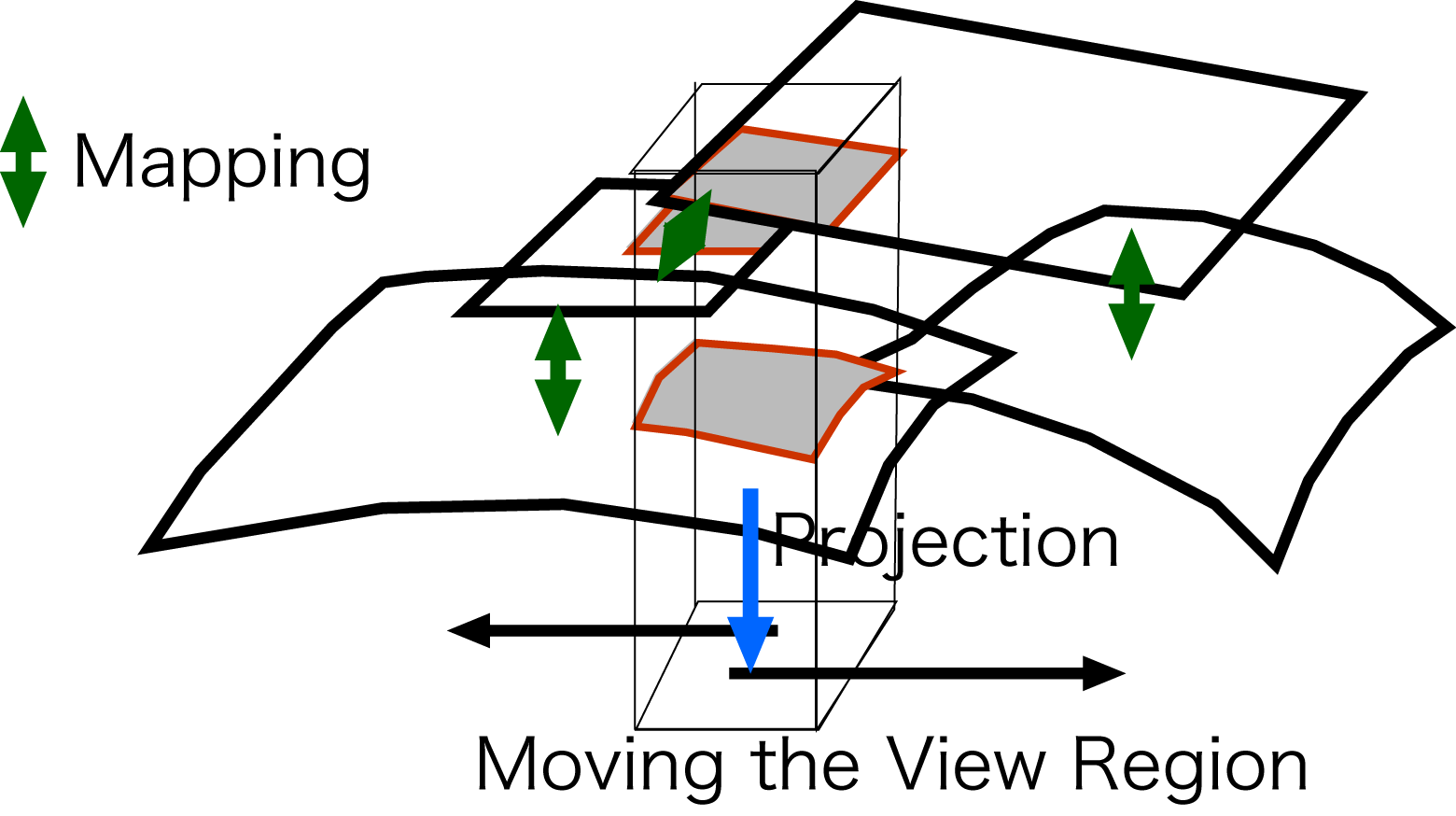
Figure Movement of browser view area
|
[UP]Go To Page Top
[6] Source Code
The architecture with the functions discussed above is implemented in the GLOBALBASE protocol, which is explained in the following. Please refer to http://www.globalbase.org/, where you can download the source code. The areas of the source code where the functions of the protocol are implemented are indicated in the explanation of the protocol given here. It is thus possible to understand the dynamics of the protocol by referring to the source code in a formal manner.
First, the configuration of the source code is briefly explained. The source code archive downloaded from the download site is named according to the format gbs.X.XX.XX.tar.gz. When you decompress this file, a directory called gbs.X.XX.XX is created. The files under gbs.X.XX.XX/env contain the source code. In the following explanation, this location is assumed to be the working directory and the location of the source code is indicated as a relative path from the working directory. The src/arch directory contains code dependent on the machine architecture and OS. Under this directory, there are subdirectories named according to the relevant operating system, such as src/arch/unix and src/arch/mac. Directories under src other than src/arch contain code independent of the machine architecture.
[UP]Go To Page Top
|
|
 |
|
|
|