 |
|
|
GLOBALBASE MANUALS >> Protocol Reference Model of GLOBALBASE Architecture: The Autonomous Decentralized GIS
Edition 2007-11-04
|
|
|
|
Protocol Reference Model of GLOBALBASE Architecture: The Autonomous Decentralized GIS
Author: Hirohisa MORI joshua at globalbase.org +
* Abstract and Goal
* Human Requirement
* System Requirement
* Introduction
* GLOBALBASE Functions
* Protocol Layering
* Security Consideration
* References
* History
Abstract and Goal
The GLOBALBASE Architecture connects geographical and spatial information delivered from numerous servers in a seamless manner and provides a novel autonomous decentralized network-type GIS that allows information searchers ( clients) to browse for information in a virtual space called "Earth" existing on the internet.
Since information providers can start up servers freely within this architecture without being restricted by a spatial information control center, the architecture has significantly higher freedom compared to conventional network-type GISs. We call the project that uses this architecture to actually accumulate spatial information of the entire world and create a virtual Earth on the Internet, the GLOBALBASE project.
In this Request for Comments ( RFC), the functions necessary for building this architecture are discussed and a protocol stack designed to achieve such functions are shown in order to receive your opinions. Moreover, we would like to have a System ( Well-Known) Port number ( No. 794if possible) to be assigned for the XL protocol implemented on top of TCP/IP in the proposed protocol stack.
[UP]Go To Page Top
Human Requirements
Engineer or Researcher
[UP]Go To Page Top
System Requirements
[UP]Go To Page Top
Introduction
GLOBALBASE is not the first attempt to share geographical information. Various technologies, for instance Web GIS, already exist. All the existing technologies, however, are based on centralized architectures.
Fig.(Centralized Type 1.)shows the simplest quasi-centralized architecture, where all geographical information is collected and stored on one server. Fig.(Centralized Type 2.)shows a slightly developed architecture, where the basic geographical information is stored on different servers, and the central server handles only searching and overlapping of target maps. This architecture employs a so-called clearing house method.
Both methods have bottlenecks on the server side. Quantitative bottlenecks, such as CPU processing power and network communication speed, are solved as a matter of course as the technologies are improved. However, we believe that qualitative bottlenecks, which are impossible to solve simply by upgrading the hardware, also exist in these technologies.
Currently, there are many map sites found on the WWW. However, if one sends a request to the administrators of such sites saying "I am interested in stores in the Edo period. Can you place such information on your site?," then, immediately, s/he will probably get a reply along the lines of "Our site focuses only on current information and as far as we know there is no demand for ancient information. We are sorry, but we cannot support such information." This is a qualitative bottleneck. We think that there may be many people interested in Japanese history, however, and if such information were available on maps, it might become rather popular.
Problems such as the one outlined above, and other similar problems, will not occur if it were possible for anyone to deliver geographical information of one's own liking on one's own homepage, in the same way as when creating a personal homepage.
"I" can deliver information on stores in the Edo period without constraint. Many people interested in history will look at this information and set forth on a romantic journey through history. They can look around many places of historic interest and take a break at a coffee shop near a historical site found on the GLOBALBASE Mapion when tired. Both the current coffee shops and ancient teahouses can be displayed in the same window.
One of the purposes of GLOBALBASE is to solve this qualitative bottleneck. Fig.(The Fully Autonomous Distributed Architecture Pursued by GLOBALBASE)shows an overview of the architecture. Information providers have their own sites and homes, and deliver their own geographical information about their areas freely. Viewers of information enter search conditions according to their interests, and scroll around with the browser to obtain necessary information. There is no restraining bottleneck between the information providers and the viewers. Information will be linked like an amalgam and will develop just like a living organism. People will perform their activities in the GLOBALBASE framework just like they do in the real world. In this way, another Earth, parallel to our own, may be completed.
When we think about it, this is a natural world for the Internet. In the framework of the GIS architectures established so far, however, this could not have been achieved.
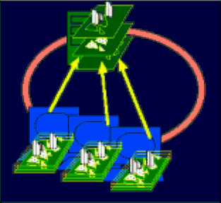
Figure Centralized Type 1.
|
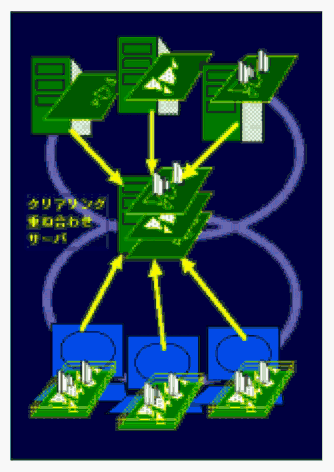
Figure Centralized Type 2.
|
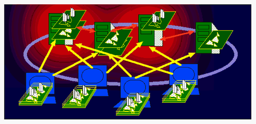
Figure The Fully Autonomous Distributed Architecture Pursued by GLOBALBASE
|
[UP]Go To Page Top
History
Date:2007-11-04
Generate the Manual (Edition 2007-11-04)
--
Date: 2007-08-01
Author: Hirohisa MORI / TargetVersion: ver.A.
Starting to write this manual.
--
[UP]Go To Page Top
|
|
 |
|
|
|